
Why Hike Valley of Fire?
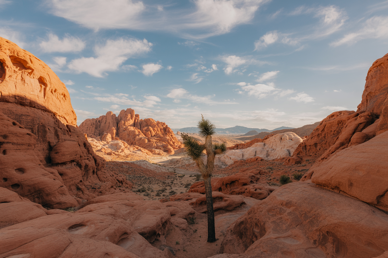
Valley of Fire State Park, located just an hour northeast of Las Vegas, Nevada, is the state’s oldest and largest state park but it feels like stepping onto another planet.
With its fiery red Aztec sandstone formations, wind-carved arches, multicolored cliffs, and petroglyphs etched by the Ancestral Puebloans over 2,000 years ago, Valley of Fire is a dream for hikers, photographers, and outdoor lovers.
But as breathtaking as it is, this desert environment is also unforgiving.
The climate can be extreme, the terrain rugged, and the wildlife both fascinating and dangerous.
If you’re planning to hike here, preparation is absolutely essential.
Let’s cover the fundamentals before diving into the trails.
Climate
Valley of Fire has a harsh Mojave Desert climate.
- Summer (May–September): Daytime highs regularly soar above 110°F (43°C). Heatstroke is a serious risk, especially for unprepared hikers.
- Winter (December–February): Daytime temps average 55–65°F (13–18°C), with nights dropping close to freezing.
- Spring/Fall: The best seasons to hike, with moderate temperatures ranging from 65–85°F (18–29°C).
Geology
The park is named for its Aztec Sandstone, a Jurassic-era rock formation formed 150 million years ago from massive shifting sand dunes.
Over time, erosion shaped the fiery cliffs, slot canyons, and arches you see today. Some rocks shimmer pink, orange, and purple a natural rainbow caused by minerals in the sandstone.
Wildlife Hazards
While most wildlife in Valley of Fire is shy, hikers need to be alert:
- Rattlesnakes: Western diamondbacks and Mojave green rattlesnakes live here. They usually avoid humans but may hide in rocks or trailsides. Always watch where you step.
- Scorpions & Spiders: Desert hairy scorpions and black widows are present — check shoes and gear.
- Coyotes & Bighorn Sheep: Generally not dangerous, but never feed them.
- Heat Risks: The biggest danger isn’t an animal it’s dehydration and sun exposure.
Navigation Challenges
Unlike lush forest trails, desert trails can be tricky to follow:
- Few landmarks: Sandstone slickrock can make paths hard to see.
- Sparse shade: Long stretches are exposed.
- Limited signage: While main hikes are marked, side trails may be confusing.
- No water sources: You must carry all your water.
In short: Valley of Fire is stunning but unforgiving. Come prepared with hydration, sun protection, navigation tools, and an understanding of the desert environment.
Now let’s dive into the 5 best hikes in Valley of Fire, explained in full detail.
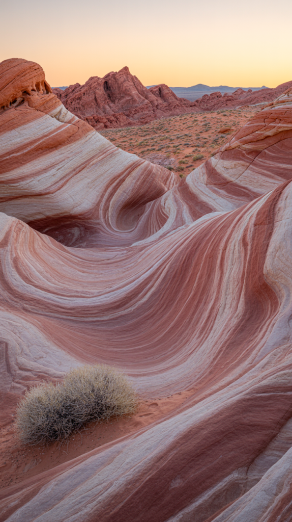
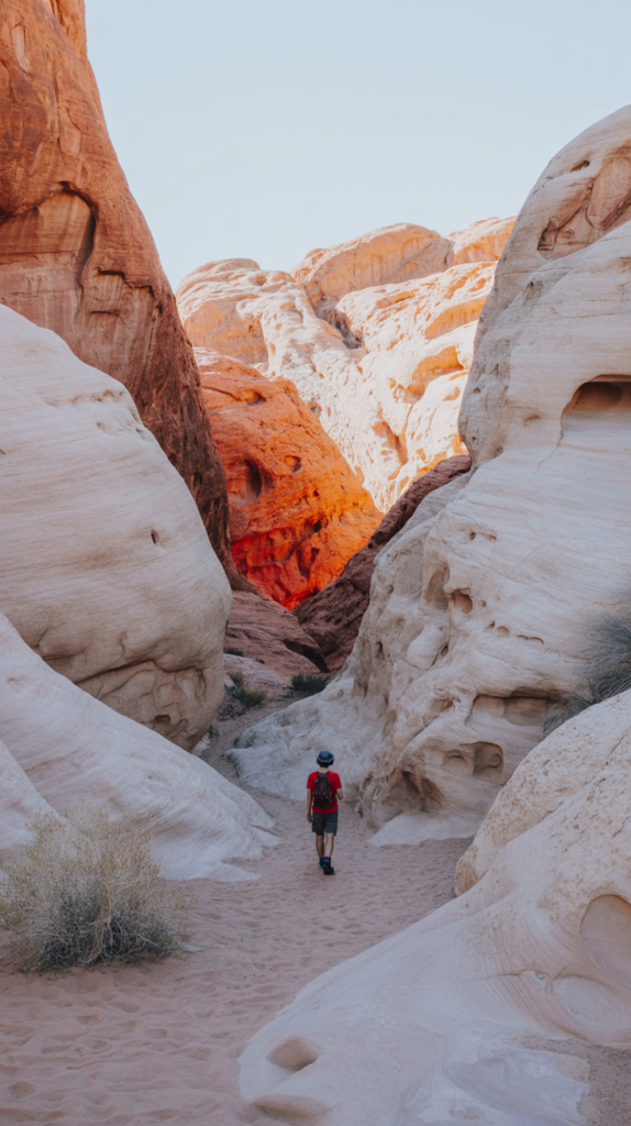
1. Fire Wave Trail
1. How to Get There
The Fire Wave Trailhead is located near Parking Lot #3 along White Domes Road (Mouse’s Tank Road). If you’re entering from the West Entrance:
- Drive about 4.7 miles and turn left onto White Domes Road.
- Continue 4.5 miles the trailhead will be on your right, clearly signed.
GPS coordinates: 36.4856° N, 114.5328° W
Parking is limited (about 15–20 spaces). If it’s full, come earlier in the day or park farther up White Domes Road and walk back.
2. When to Go
- Best season: October through April when temps are mild.
- Avoid: June–September midday it’s dangerously hot.
- Best time of day: Sunrise for solitude or sunset for glowing rock formations.
3. Safest Hiking Path to Take
This is a 1.5-mile round trip out-and-back trail with minimal elevation gain (~175 feet).
- The path begins sandy, winding through desert scrub.
- Soon you’ll step onto slickrock smooth sandstone. Follow the wooden stakes with arrows.
- The trail ends at the “Fire Wave” swirling red and white sandstone resembling ocean waves frozen in stone.
Safety tip: The slickrock radiates heat like an oven. In summer, surfaces can burn skin through thin shoes.
4. Distance & Duration
- Distance: 1.5 miles (2.4 km)
- Duration: 45 minutes to 1.5 hours, depending on pace and photo stops.
5. Cost Breakdown
- Entrance: $10 per NV vehicle / $15 per out-of-state vehicle.
- Gear costs: $30–$150 if you need hydration packs, sunscreen, hats.
- Optional guided hike: $40–$80 per person.
6. Essential Hiking Tips
- Always bring more water than you think.
- Wear light-colored clothing to reflect sun.
- Avoid sandals you need grip on slickrock.
- Respect nature climbing on the Fire Wave damages fragile stone.
7. Tools & Lifesaving Gear
- Shoes: Salomon X Ultra 4 GTX (grippy & breathable).
- Backpack: Osprey Daylite Plus 20L.
- Hydration: Hydro Flask Trail Series 24oz (insulated to keep water cool).
- GPS/Communication: Garmin inReach Mini 2 (essential where cell service fails).
8. Food & Water Prep
- Water: 2 liters per person minimum.
- Food: Salted almonds, dried mango, Clif Bars.
- Add electrolytes like Nuun Hydration Tabs to avoid cramping.
9. Accommodation Options
- Inside park: Atlatl Rock or Arch Rock Campgrounds (first-come, first-served, $20–$25/night).
- Nearby towns: Overton (~15 min drive), or Las Vegas for more amenities.
10. Pro Tips from Experienced Hikers
- Visit in winter evenings you’ll often have the Fire Wave all to yourself.
- Bring a tripod if photographing sunset low light demands stability.
- Watch for lizards basking on the rocks near the wave.
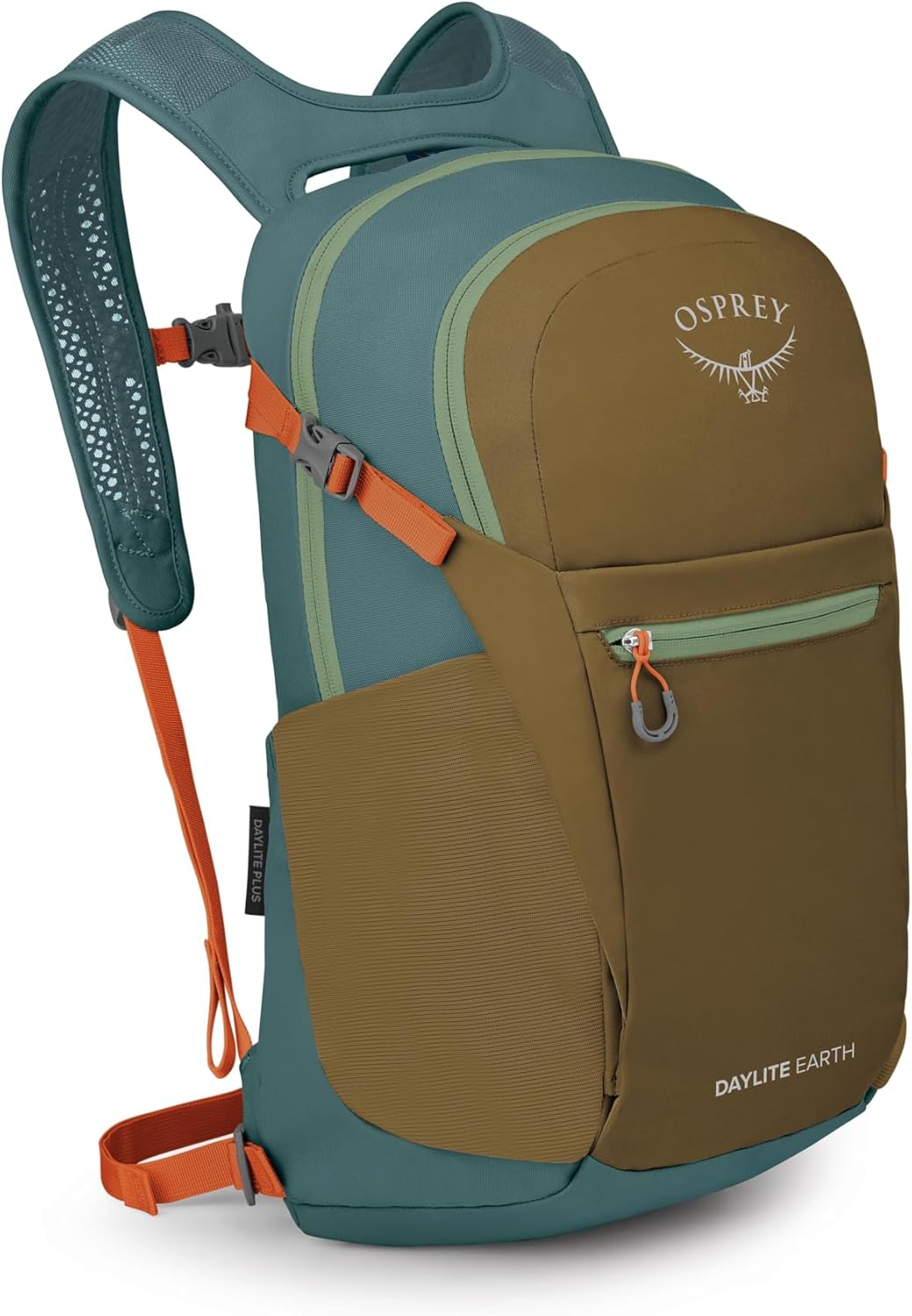
Backpack
This backpack is perfect for both everyday use and travel. It’s spacious, durable, and equipped with multiple compartments for optimal organization, ensuring you can carry your essentials in style and comfort.
Get it on Amazon2. White Domes Trail
1. How to Get There
The White Domes Trailhead is located at the end of White Domes Road (Mouse’s Tank Road), about 6 miles from the Valley of Fire Visitor Center.
- Enter the park through the West Entrance.
- Drive northeast for about 4.7 miles.
- Turn left onto White Domes Road.
- Drive 6 miles until the road ends at the White Domes parking lot.
The parking lot is paved, with bathrooms, picnic tables, and space for around 30 vehicles. It can fill up fast during weekends.
GPS coordinates: 36.4733° N, 114.5281° W
2. When to Go
- Best season: Late fall through spring (October–April).
- Best time of day: Late afternoon for glowing canyon walls.
- Avoid: Midday in summer the canyon traps heat.
3. Safest Hiking Path to Take
The White Domes Trail is a 1.1-mile loop with about 150 feet of elevation gain.
- Begin at the trailhead, descending stone steps into a sandy wash.
- You’ll pass the remains of a 1960s film set (The Professionals), a quirky highlight.
- Continue through open desert before entering a short slot canyon about 200 feet long.
- The canyon narrows dramatically, with towering sandstone walls this is the most photographed section.
- After the canyon, the loop reconnects with the parking lot.
Safety warning: Avoid this trail after heavy rainfall. Flash floods can occur in the slot canyon.
4. Distance & Duration
- Distance: 1.1 miles (1.8 km) loop
- Duration: 45–75 minutes depending on pace and photo stops
5. Cost Breakdown
- Entrance fee: $10 (NV residents) / $15 (non-residents).
- Optional costs: guided hikes (~$40–$70 per person).
- Parking: Free at trailhead.
6. Essential Hiking Tips
- Wear closed-toe hiking shoes for sandy washes and rocky descents.
- Carry a flashlight or headlamp if hiking at dusk.
- Bring a hiking partner slot canyons are best explored in pairs.
- Respect the fragile desert environment. Don’t carve or mark canyon walls.
7. Tools & Lifesaving Gear
- Shoes: Merrell Moab 3 Mid Waterproof Boots.
- Poles: Black Diamond Trail Trekking Poles (for descent).
- Lighting: Black Diamond Spot 400 Headlamp.
- Emergency kit: Adventure Medical Kits Ultralight/Watertight .7
8. Food & Water Prep
- Water: 1.5 liters per person (minimum).
- Food: Light snack trail mix, Clif Shot Bloks, or beef jerky.
- Electrolytes: Nuun Hydration Tabs for hot days.
9. Accommodation Options
- Inside park: Atlatl Rock Campground (~3 miles away).
- Nearby: Hotels in Overton (15 min) or Mesquite (1 hr).
- Las Vegas: 1 hour drive if you prefer city accommodations.
10. Pro Tips from Experienced Hikers
- Hike clockwise descending stone steps is easier than climbing up.
- The slot canyon is cooler than the rest of the park great place to escape midday sun.
- Bring a wide-angle lens if you’re a photographer the canyon is narrow.

Hiking Shoes
These hiking shoes are built for comfort, stability, and all-day support on the trail. With durable construction and reliable traction, they’re perfect for hiking, camping, and outdoor adventures where sure footing and comfort matter most.
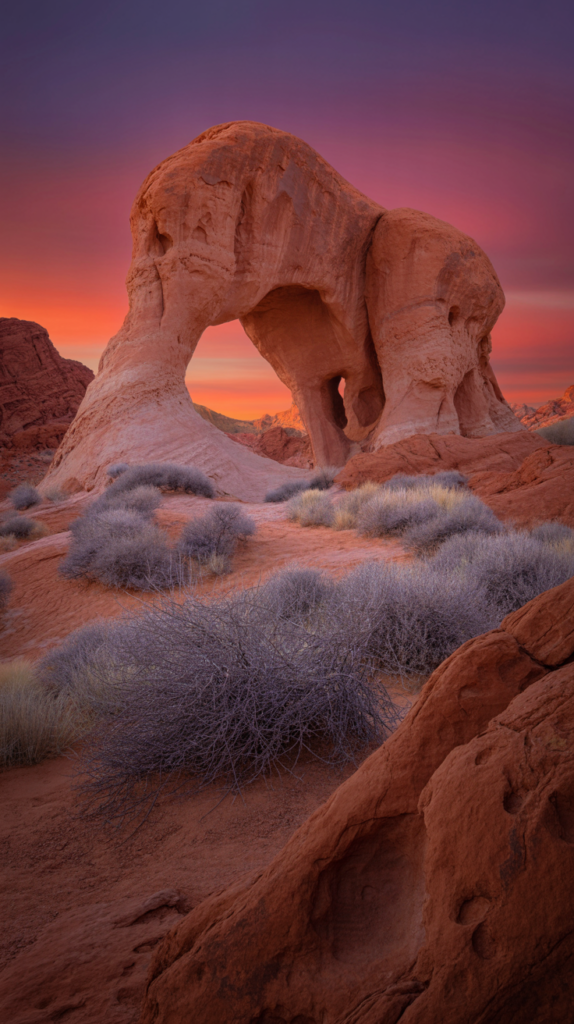
Get it on Amazon3. Elephant Rock Trail
1. How to Get There
Elephant Rock is located just inside the East Entrance of Valley of Fire.
- From the Visitor Center, drive 3.8 miles east along the main road.
- Turn right toward the East Entrance booth.
- The small parking lot for Elephant Rock is just past the fee station.
GPS coordinates: 36.4255° N, 114.5147° W
2. When to Go
- Best season: All year round (trail is very short).
- Best time of day: Sunrise or sunset when the arch glows orange.
- Avoid: Midday in summer short hike but no shade.
3. Safest Hiking Path to Take
The Elephant Rock Trail is a 0.3-mile loop with minimal elevation gain.
- Begin from the parking area and follow the signs.
- The trail leads you through desert scrub to the natural arch formation shaped like an elephant.
- You can continue the loop back to the parking lot or return the way you came.
Important: Climbing on the rock is prohibited. It’s fragile and at risk of collapse.
4. Distance & Duration
- Distance: 0.3 miles (0.5 km)
- Duration: 15–30 minutes
5. Cost Breakdown
- Covered by park entry fee.
- No other mandatory costs.
6. Essential Hiking Tips
- Great trail for families with children.
- Wear sturdy shoes; sandstone edges can be sharp.
- Bring a camera it’s one of the most photogenic formations in the park.
7. Tools & Lifesaving Gear
- Shoes: Altra Lone Peak 7 Trail Runners.
- Hydration: CamelBak Hydrobak Light 1.5L Pack.
- Camera gear: Sony Alpha a7 IV + Manfrotto Befree Tripod.
8. Food & Water Prep
- 0.5 liters water (minimum).
- Small snack like fruit or nuts.
9. Accommodation Options
- Closest: Valley of Fire campgrounds.
- Nearby towns: Overton or Logandale (~20 minutes).
10. Pro Tips from Experienced Hikers
- Frame Elephant Rock against the sunrise for dramatic photos.
- If visiting at sunset, bring a flashlight for the walk back to your car.
- Avoid climbing or leaning on the rock rangers do monitor this area.

Trekking Pole
This trekking pole provides extra stability and reduces strain on your knees during hikes and long walks. Lightweight, adjustable, and easy to pack, it’s ideal for hiking, trekking, and outdoor adventures on varied terrain.
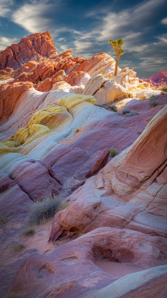
Get it on Amazon4. Rainbow Vista Trail
1. How to Get There
Rainbow Vista Trailhead is located along White Domes Road, about 5 miles from the Visitor Center. The trailhead has a small gravel parking lot for ~20 cars.
GPS coordinates: 36.4601° N, 114.5313° W
2. When to Go
- Best season: October–April.
- Best time: Sunrise or sunset for glowing multicolored rocks.
- Avoid: Midday heat in summer.
3. Safest Hiking Path to Take
The Rainbow Vista Trail is a 1-mile round trip hike over sandy washes and slickrock.
- Begin from the parking area and follow the sandy path.
- The trail leads to a panoramic overlook with sweeping views of rainbow-colored sandstone formations.
- Trail is exposed with no shade.
Safety note: Sand can make walking more strenuous — wear gaiters if hiking in windy conditions.
4. Distance & Duration
- Distance: 1 mile (1.6 km)
- Duration: 40–60 minutes
5. Cost Breakdown
- Covered by park entry fee.
- Optional: Professional photo tours (~$150–$250).
6. Essential Hiking Tips
- Wear breathable clothing; the sand radiates heat.
- Bring a wide-brim hat and strong sunscreen.
- Avoid hiking barefoot on sand it gets scorching hot.
7. Tools & Lifesaving Gear
- Shoes: HOKA Anacapa Low GTX.
- Sun protection: Sunday Afternoons Adventure Hat.
- Hydration: Osprey Hydraulics 2L Reservoir.
8. Food & Water Prep
- Water: 1–1.5 liters per person.
- Snacks: Protein bars, salted pretzels.
9. Accommodation Options
- Inside park: Arch Rock Campground.
- Nearby towns: Overton, Logandale, or Mesquite.
10. Pro Tips from Experienced Hikers
- Visit at sunset rocks glow pink, orange, and purple.
- Bring polarized sunglasses to reduce glare off sandstone.
- Great spot for astrophotography night skies are crystal clear.

Binoculars
These binoculars deliver clear, sharp views for hiking, wildlife watching, sightseeing, and outdoor adventures. Lightweight and easy to focus, they’re perfect for capturing distant details without carrying bulky gear.
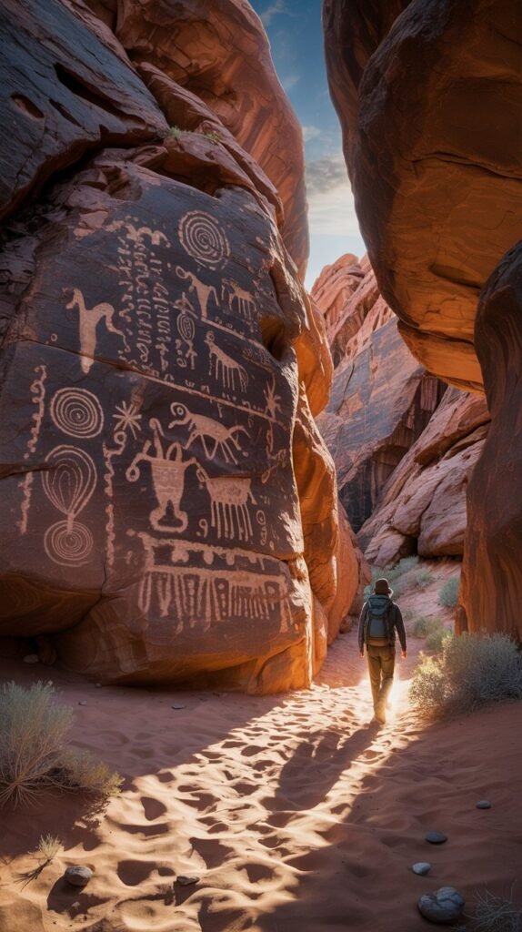
Get it on Amazon5. Mouse’s Tank Trail (Petroglyph Canyon)
1. How to Get There
The Mouse’s Tank Trailhead is on White Domes Road, about 1 mile from the Visitor Center. The parking lot has restrooms and shaded picnic tables.
GPS coordinates: 36.4507° N, 114.5321° W
2. When to Go
- Best season: Fall through spring.
- Best time: Early morning (cooler, fewer crowds).
- Avoid: Summer afternoons when sandy wash feels like an oven.
3. Safest Hiking Path to Take
Mouse’s Tank Trail is a 0.8-mile round trip sandy walk through Petroglyph Canyon.
- Trail is flat but sandy walking can be slow.
- Canyon walls feature hundreds of petroglyphs (rock carvings).
- Trail ends at Mouse’s Tank a natural rock basin that collects rainwater.
Safety warning: Do not touch petroglyphs oils from skin damage them.
4. Distance & Duration
- Distance: 0.8 miles (1.3 km)
- Duration: 30–45 minutes
5. Cost Breakdown
- Covered by park entry.
- Optional petroglyph tours: $50–$100 per person.
6. Essential Hiking Tips
- Bring binoculars to see high-up petroglyphs.
- The sandy trail is hot wear lightweight boots or gaiters.
- Go slow and scan walls carefully many carvings are subtle.
7. Tools & Lifesaving Gear
- Binoculars: Nikon Prostaff P7 8×42.
- Shoes: Keen Targhee Vent Hiking Shoes.
- Backpack: Deuter Speed Lite 20.
8. Food & Water Prep
- Water: 1 liter per person.
- Snacks: Energy chews, fruit, nuts.
9. Accommodation Options
- Inside park: Atlatl Rock Campground.
- Nearby towns: Overton (closest) or Las Vegas (1 hour).
10. Pro Tips from Experienced Hikers
- Petroglyphs are best viewed in angled morning light shadows reveal details.
- If the basin holds water, watch for desert wildlife.
- Some carvings are thousands of years old take photos, not souvenirs.

Water Filter
This portable water filter provides clean, safe drinking water wherever your adventures take you. Ideal for camping, hiking, backpacking, and emergency kits, it effectively removes impurities so you can stay hydrated with confidence.
Get it on AmazonFinal Thoughts
Valley of Fire State Park is a must-hike destination for anyone visiting Nevada.
From the surreal swirls of the Fire Wave to the cultural richness of Mouse’s Tank Petroglyph Canyon, each trail tells a unique story of geology, history, and desert life.
Hiking here isn’t just about fitness it’s about respecting a fragile desert ecosystem.
Carry plenty of water, wear the right gear, and stay on marked trails.
With preparation, you’ll experience the park’s fiery beauty safely and leave with memories that last a lifetime.

Water Filter
This portable water filter provides clean, safe drinking water wherever your adventure takes you. Lightweight and easy to use, it’s perfect for hiking, camping, travel, and emergency preparedness.
Get it on Amazon