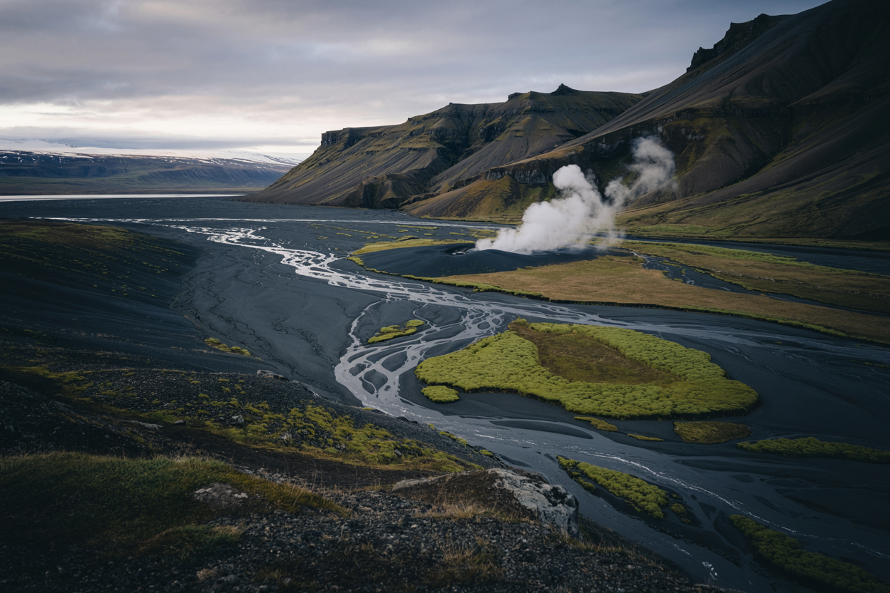
Iceland’s dramatic landscapes are famous lava fields, roaring waterfalls, black-sand beaches and northern lights.
But beyond the Golden Circle and the South Coast highlights there are quieter, stranger, more intimate places where you’ll meet solitude, local stories, and landscapes that feel like private screenings of the planet’s best visuals.
Here are 13 hidden gems chosen for natural wonder, accessibility (with a bit of planning), and that special “Icelandic secret” vibe with the nuts-and-bolts every traveler needs.
Quick list (so you can jump to sections)
- Hornstrandir Nature Reserve (Westfjords)
- Rauðisandur — the Red/Gold Beach (Westfjords)
- Stuðlagil Canyon (Jökuldalur, East Iceland)
- Djúpavík (Strandir coast, Westfjords)
- Seyðisfjörður (East fjords — artsy harbour town)
- Hvitserkur (the “drinking dragon” sea stack, North)
- Kerlingarfjöll (Highlands geothermal ridges)
- Þórsmörk / Thorsmork (sheltered alpine valley, hikers’ paradise)
- Borgarfjörður Eystri (puffins, hiking & rhyolite peaks)
- Ásbyrgi (horseshoe canyon, north)
- Þakgil (hidden canyon & campsite south of Vík)
- Kvernufoss (quiet waterfall near Skógar)
- Vök Baths (Geothermal floating baths, Egilsstaðir area)
How to use this guide
- Each section contains: what makes it special, where it is, approximate distance/time from Reykjavík (or nearest hub), population (if the place is a town), access tips, best seasons, how long to plan, nearby services/accommodation, and top traveler tips.
- I researched official and reputable local sources for key facts (see citations in the text). If you want a printable single-page checklist or a mapping-ready itinerary, I can make one right away.
1) Hornstrandir Nature Reserve — The last true wilderness (Westfjords)
Why go: Raw, cliff-dominated coastline, breeding seabirds, Arctic foxes, and empty hiking trails — a place where the only crowds are seabirds and the occasional ranger.
It’s dramatic, solitary and otherworldly.
Where & size: Hornstrandir is the northernmost peninsula of the Westfjords and is protected as a nature reserve covering roughly 580 sq km (≈220 sq mi) of tundra, cliffs and coastline.
It is uninhabited year-round; human settlements exist only as seasonal summer crofts.
Distance & access: You’ll reach Hornstrandir by boat from Ísafjörður or other Westfjords ports.
Ísafjörður itself is ~450–470 km by road from Reykjavík (depending on route) and is the Westfjords’ main hub allow half a day driving from Reykjavík to Ísafjörður, or fly to Ísafjörður in summer from Reykjavík domestic airport.
Population & services: Hornstrandir has no permanent population. Bring everything you need; minimal facilities in the reserve.
Ísafjörður is the nearest town for supplies and guides.
Best time: Late May–September (boats run more reliably in summer; tundra flowers July–August).
How long to plan: Multi-day hikes (3–7 days) to fully experience remote coves. Day tours are possible but give you only a taste.
Top tips:
- Book boat transfers and any ranger-guided trips in advance.
- There are no roads; dress for wind and rapid weather changes; bring a GPS or reliable map & compass.
- Respect nesting birds and keep distances from colonies.
2) Rauðisandur — the golden (sometimes red) stretch of sand (Westfjords)
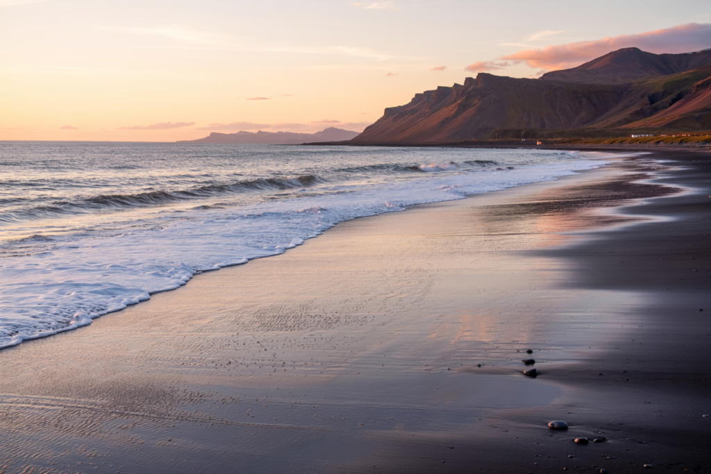
Why go: Vast, gentle beach sand that ranges in tone from pale gold to deep red depending on minerals and light. You can walk for miles without seeing another soul; the scale is cinematic.
Where & size: Rauðisandur’s shoreline stretches for several kilometers many guides and photographers note it to be about ~7 miles (≈11 km) in length from vantage points, though the “usable” beach varies by tide and access path.
Distance & access: Located in the southern arm of the Westfjords.
From Ísafjörður the drive can be long and winding; plan for several hours with variable gravel roads; some parts are best reached by scenic detours from Patreksfjörður or Bíldudalur depending on your starting point.
Population & services: The nearest settlements are small Westfjord villages services are limited; bring supplies or stay in nearby towns.
Best time: Summer for long, wind-less days; early morning and evening light make for gorgeous photography.
How long to plan: 2–4 hours for a long walk, half or full day if you explore small coves; overnighting in nearby towns recommended.
Top tips:
- Check tide times if you plan coastal hikes.
- The color of the sand changes with light and moisture — check sunrise/sunset times for great photos.
- Wildlife: seals and sea birds often rest on the beach; keep a respectful distance.
3) Stuðlagil Canyon — Iceland’s basalt cathedral (East Iceland)
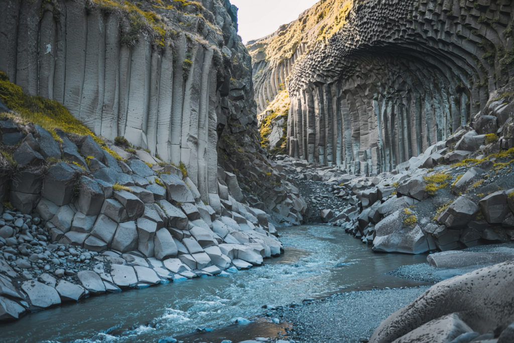
Why go: Walls of towering basalt columns flanking a bright turquoise glacial river photogenic, dramatic and geologically fascinating.
Where: Stuðlagil is in the Jökuldalur valley in East Iceland, carved by the Jökulsá á Dal (Jökla) river.
The canyon’s hexagonal basalt column formations rise vertically from the riverbed a rare and spectacular example of columnar basalt. Wikipedia
Access & distance: Stuðlagil is in East Iceland along the route between Egilsstaðir and Mývatn from Reykjavík it’s a long drive (typically 6–8+ hours depending on stops).
The canyon is accessed via short hikes from parking areas; vehicular access may include gravel roads.
Best time: Summer and early autumn for clearer water tones (glacial silt concentration affects color).
Winter access is possible but more challenging and requires caution.
How long to plan: 2–4 hours for a visit; half to full day if combining photography and short hikes.
Top tips:
- The turquoise color of the river is seasonal check local reports and weather (low-flow summer days often show the brightest color).
- Wear sturdy boots — basalt is slippery when wet.
- Bring polarized sunglasses or lens filter for photography.
4) Djúpavík — abandoned herring factory & cinematic isolation (Strandir, Westfjords)
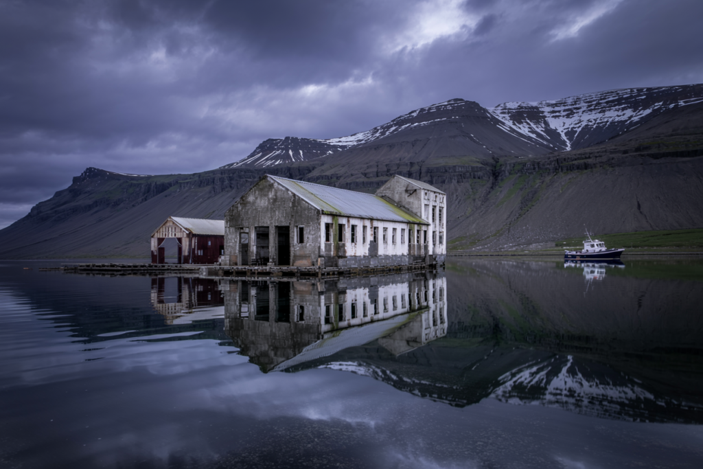
Why go: An eerie, atmospheric village one main ruined herring factory turned into evocative, photo-ready ruins and a small hotel.
Perfect for fans of history, photography and the uncanny.
Where & population: Djúpavík sits at the head of Reykjarfjörður on Strandir coast.
The municipality Árneshreppur is one of Iceland’s least populous it covers a large area with a very small population; the municipality population has been reported around ~50 people, and the village itself today has just a handful of permanent houses plus a hotel.
Distance & access: Very remote long drives on gravel F-roads may be required depending on route.
There’s limited air service to Gjögur in summer; most visitors arrive by car from Ísafjörður or Þingeyri with long driving legs.
Best time: Summer for safe roads and better weather; some remote services operate seasonally.
How long to plan: Half day to a full day to explore the factory ruins, the little hotel and nearby coastline. Overnighting adds perfect golden-hour and night photography.
Top tips:
- The ruins are interesting be mindful of unstable structures and stick to safe areas.
- Check fuel availability; remote Westfjords require careful logistic planning.
- Book accommodation well ahead in high season (July–August).
5) Seyðisfjörður — artsy fjord town with a cinematic harbor (East fjords)
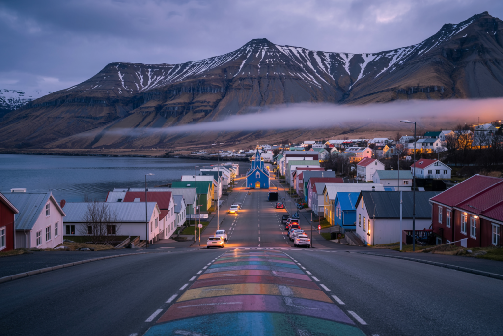
Why go: Colorful wooden houses, a creative arts scene, waterfalls within walking distance from town and the ferry link to the Faroe Islands/Denmark charming and accessible.
Where & population: Seyðisfjörður sits at the head of its fjord in East Iceland.
Recent estimates put the town population around ~640–790 residents (estimates vary slightly by year; ~676 recorded in 2018 and ~648–790 in various 2024 figures).
The town is about 27 km from the Ring Road and Egilsstaðir via Fjarðarheiði pass.
Distance & access: From Reykjavík it’s a long drive (6–7+ hours), but many travelers combine it with East Iceland itineraries.
The Norröna ferry sails to Seyðisfjörður in summer/autumn giving another route option.
Best time: Summer and shoulder seasons for hiking and festivals; winter for dramatic fjord storms and auroras (roads over passes can close).
How long to plan: 1–2 nights to enjoy the town; 3–5 days to explore surrounding hikes and fjords.
Top tips:
- The main waterfall hiking path from town is a must-do — you can reach several scenic cascades within 1–2 hours.
- Try local cafes and small artisan shops; the town punches above its size for cultural offerings.
- Check ferry schedules and road-pass conditions in winter.
6) Hvitserkur — the “rock dragon” sea stack (Northwest coast)
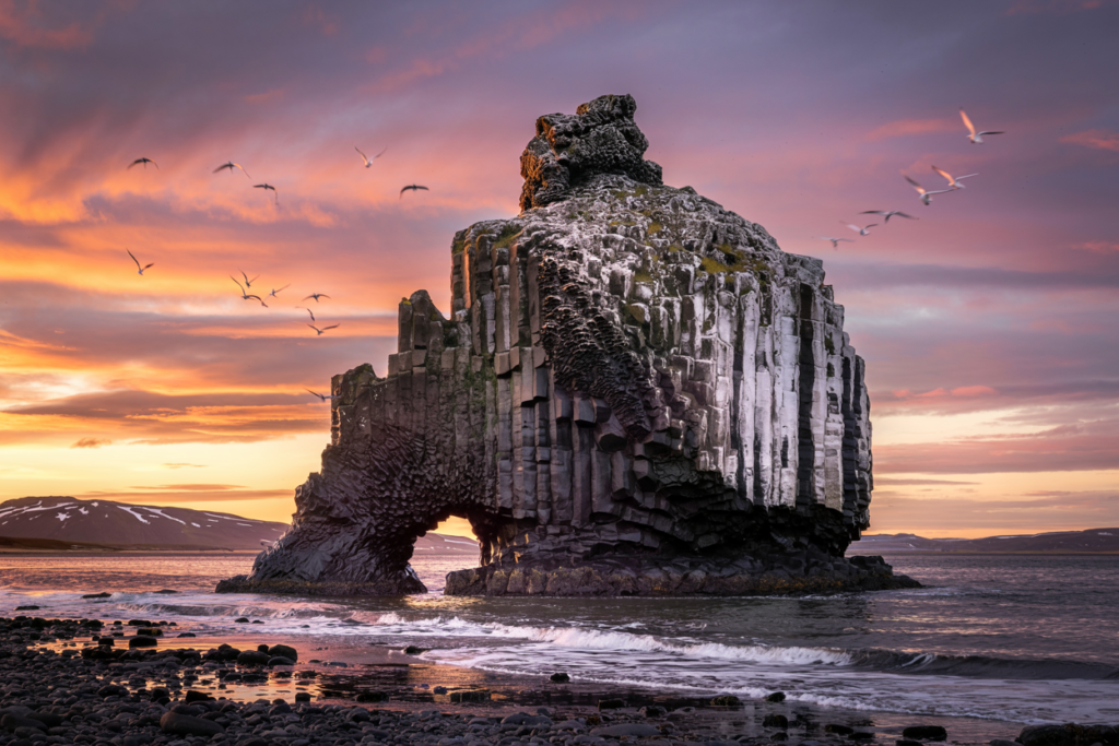
Why go: A 15-meter basalt sea stack shaped by wind and waves into a dramatic silhouette popular with photographers for sunrise and sunset shots and its unique form (often likened to a dragon drinking).
Where & size: Hvitserkur rises from the sea off the Vatnsnes peninsula in northwest Iceland.
The formation is about 15 m (≈50 ft) tall and is an impressive coastal landmark.
Distance & access: Drive from Reykjavík ~3–4 hours to the Vatnsnes area (depending on route).
Short walk from the parking area to the viewpoint; tidal awareness is useful if you plan to approach the stack.
Best time: Summer for seabirds and calmer seas; winter for dramatic waves and aurora photos (but cold & windy).
Top tips:
- Combine with seal-watching on Vatnsnes and local craft museums.
- Low tide gives more beach access for close photography; always be careful of waves.
7) Kerlingarfjöll — red rhyolite ridges and geothermal sculptures (Highlands)
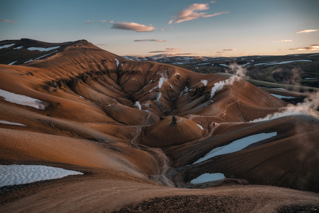
Why go: Vivid red rhyolite mountains, steaming geothermal vents and surreal highland landscapes an out-of-the-way alternative to Landmannalaugar with far fewer people if you time it right.
Where & access: Located in the Icelandic Highlands (central highland area).
Access requires a 4×4 vehicle and is generally possible in summer months only (F-roads).
Kerlingarfjöll sits roughly in the central highlands between the Golden Circle and the north interior; expect long driving legs on gravel and interior roads.
Best time: Summer (June–September) when F-roads are open.
How long to plan: 1–2 nights if you want to hike multiple trails and soak in the scenic hot springs.
Top tips:
- Bring a 4×4 and check road conditions; some tours operate from Reykjavík if you prefer not to drive.
- Weather can change fast — pack layers and waterproofs.
- If you want solitude, go mid-week and early/late season.
8) Þórsmörk (Thorsmork) — the hikers’ hidden garden
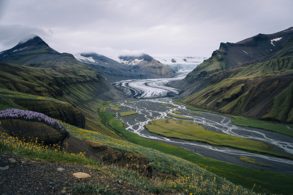
Why go: A sheltered alpine valley flanked by glaciers and ridges, full of trails, ridgelines and dramatic views a hiking mecca that requires fording glacial rivers (or taking shuttle buses) and rewards with remote scenic trails.
Where & access: Þórsmörk is south of the Mýrdalsjökull glacier. Access typically requires high-clearance vehicles crossing glacial rivers (F-roads) or using scheduled buses from Hvolsvöllur/Skógar.
The valley sits approximately 150–200 km from Reykjavík (driving time varies with route and fording conditions).
Best time: Summer for river crossings when they’re at lower levels (but still use caution).
Popular with multi-day hikers on Laugavegurinn routes (many routes start/finish here).
How long to plan: 2–4 days for main hikes; day visits possible if using shuttles.
Top tips:
- Respect river crossing risks — use shuttle services if unsure.
- Pack mountain-grade gear and warm layers.
- Camping and refuge huts are popular — book hut spots where applicable.
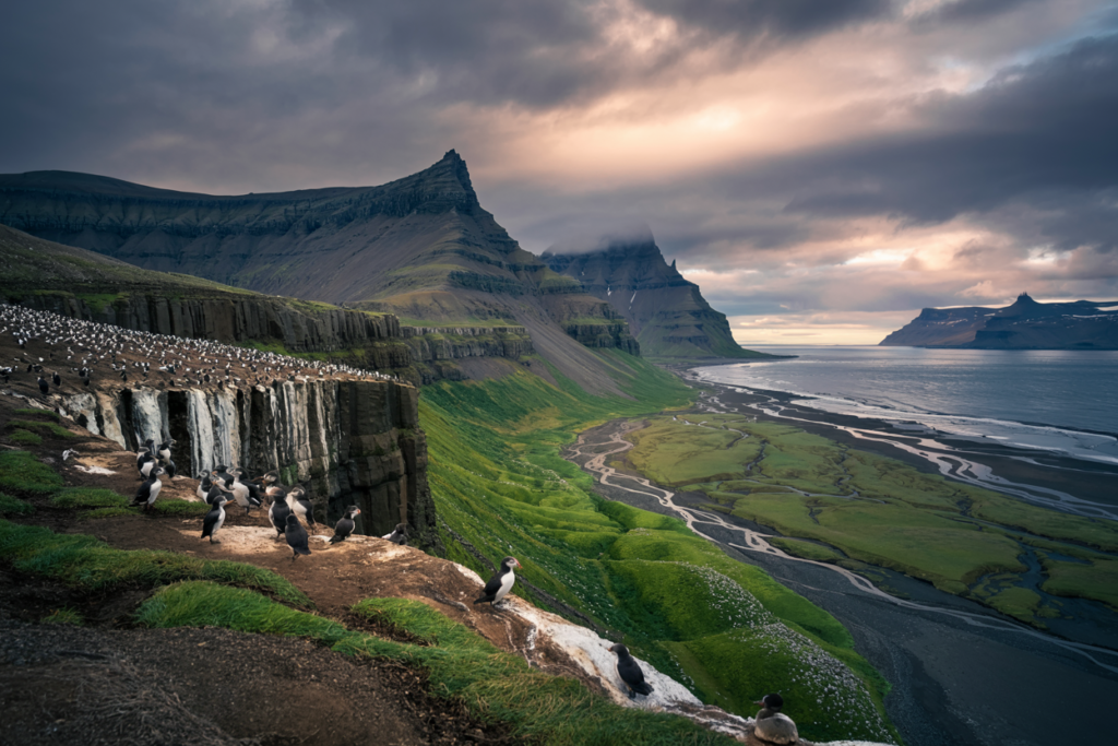
9) Borgarfjörður Eystri — rhyolite peaks & puffins (East)
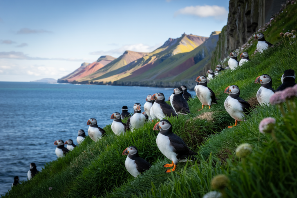
Why go: A small, friendly community surrounded by colorful rhyolite hills and home to puffin colonies and excellent hiking trails quieter than many coastal stops but incredibly scenic.
Where & population: Borgarfjörður Eystri is a small village in East Iceland with a small permanent population (a few hundred or less); it’s known for its hiking trails such as Stórurð (The Giant Boulders) and nearby puffin cliffs.
Access & distance: Off the Ring Road in the East; reachable by car from Egilsstaðir in under 2 hours depending on your starting point.
Best time: Summer for puffins (breeding season late May to August) and for hiking.
How long to plan: 1–2 days to hike Stórurð and visit puffin cliffs.
Top tips:
- Bring binoculars for bird watching.
- Trails can be rocky and require good boots.
10) Ásbyrgi — a natural horseshoe canyon in the north
Why go: A dramatic horseshoe-shaped canyon with cliffs, birch forests and calm ponds; great hiking, birding and a quieter alternative to more-touristed sites.
Where & size: Part of the larger Jökulsárgljúfur area (now within Vatnajökull National Park management), Ásbyrgi is an impressive canyon forming a horseshoe about 1 km wide in places with cliffs rising up to 100 m.
(Note: size descriptions vary by source; the canyon is a standout geological formation in the north.)
Access & distance: North Iceland — near the Ring Road and accessible by car from Akureyri region in a few hours.
Best time: Summer and shoulder seasons.
How long to plan: Half to full day for hikes and viewpoints.
Top tips:
- Visit the interpretive center for geology and folklore (the canyon links with Icelandic sagas).
- Trails are well-marked; bring insect repellent in summer.
11) Þakgil — hidden canyon camping near Vík
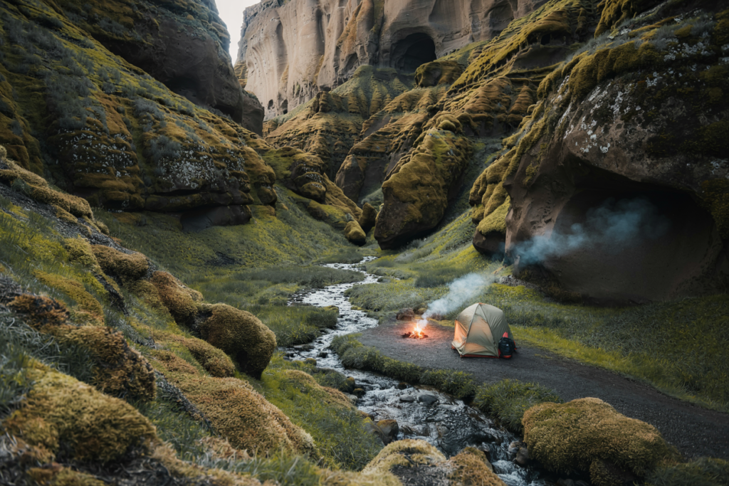
Why go: A sheltered canyon with green mossy cliffs and a lovely campsite it’s an atmospheric, less crowded complement to the black-sand beaches of the south.
Where & access: South Iceland near Vík; access via a winding gravel road requiring a high-clearance vehicle (some parts can be tricky after rain). Follow the road signs to the Þakgil campsite.
Best time: Summer campsite open and roads more reliable.
How long to plan: Overnighting at the campsite gives best experience; day visits possible.
Top tips:
- Book campsite spots in July–August.
- Roads may be closed in early/late season; check conditions.
12) Kvernufoss — a quiet waterfall near Skógar
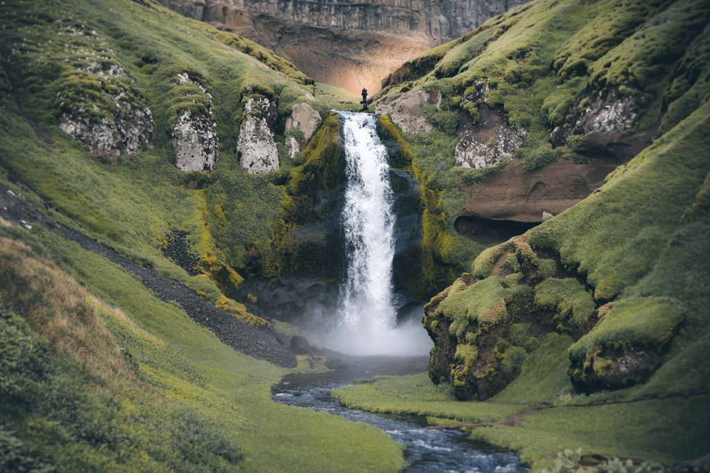
Why go: A short, lesser-known waterfall tucked behind cliffs where you can walk behind the curtain of water you’ll often have the place to yourself despite being near the popular Skógafoss.
Where & access: Located near the Skógar Museum and Skógafoss on the south coast, Kvernufoss is a short walk from the small parking area and is relatively easy to reach on a standard car.
Because it’s lesser-known, it’s usually much calmer than its famous neighbor.
Best time: Year-round (paths can be icy in winter).
How long to plan: 30–90 minutes including approach and photography.
Top tips:
- Wear waterproof layers if you plan to go behind the falls.
- Combine with Skógafoss, Skógar Museum and Sólheimasandur visits on the same day.
13) Vök Baths — unusual geothermal “floating” pools (East, near Egilsstaðir)
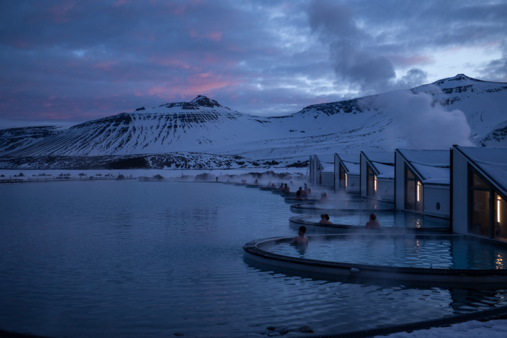
Why go: Modern geothermal baths built on a lake with floating pools a relaxing and less-touristed bathing option in East Iceland near Egilsstaðir.
Where & access: Near Egilsstaðir in East Iceland; easy drive from town and a relaxing stop if you’re exploring the eastern fjords (including nearby Seyðisfjörður).
Best time: Year-round; winter bathing under snowy skies or summer for long evenings.
How long to plan: 2–3 hours for bathing and relaxation.
Top tips:
- Book slots in high season.
- Combine with a day in Egilsstaðir or a visit to Seyðisfjörður.
Practical planning & logistics (for all 13 gems)
Vehicles & roads
- Many of these places are best reached by car. If you plan to access highland routes (Kerlingarfjöll, some approaches to Þórsmörk, interior valleys) you’ll often need a high-clearance 4×4 and experience crossing glacial rivers. If you don’t have that experience, use scheduled shuttle services or guided tours.
- Gravel (non-paved) roads are common in Westfjords and some East fjord branches; drive carefully and watch for single-lane bridges.
- Summer (June–September) is the most reliable season for access; many highland tracks (F-roads) close in winter.
Weather & clothing
- Iceland’s weather changes fast: layer up. Base layer, fleece/insulating mid-layer, waterproof/windproof outer shell, warm hat and gloves even in summer nights.
- Bring sturdy hiking boots (waterproof), gaiters for muddy tracks, and poles if you’re planning long hikes.
- For coastal wind-swept places like Hornstrandir and Hvitserkur, expect strong winds and dress accordingly.
Accommodation & services
- Remote places (Hornstrandir, Djúpavík) have very limited options — book in advance or plan to camp.
- Towns like Ísafjörður, Egilsstaðir, Seyðisfjörður and Akureyri provide full services — good bases for day trips.
- Fuel stations can be sparse in Westfjords and Strandir; top up whenever convenient.
Safety notes
- Never underestimate river crossings or sudden weather; ask local info centers about road conditions.
- Respect private land and local farming operations — many trails cross or border sheep grazing areas.
- Emergency number in Iceland: 112.
Suggested mini-itineraries (3 options)
A) Westfjords micro-adventure (5–7 days)
- Base: Ísafjörður (2 nights). Day trips: Hornstrandir boat day tour (or overnight trek), Rauðisandur and Látrabjarg cliffs (puffins in summer), Djúpavík exploration & hotel night.
B) East fjords & quiet coasts (5–7 days)
- Base: Egilsstaðir (2 nights) — day trips to Seyðisfjörður, Borgarfjörður Eystri, Stuðlagil canyon; overnight in Djúpivogur or local guesthouse; end at Vök Baths for relaxation.
C) Highlands & hidden canyons (4–6 days)
- Reykjavík → Kerlingarfjöll (2 nights) → Þórsmörk multi-day hike or day trip with shuttle → back via south coast, drop by Kvernufoss and Þakgil.
Photography & content tips
- Golden hour matters in Iceland. For beaches and sea stacks (Rauðisandur, Hvitserkur), aim for sunrise or sunset.
- For basalt columns like Stuðlagil, polarizing filters and wide-angle lenses work well.
- Drone use? Drones can capture magical shots but follow Icelandic drone rules and local restrictions (especially near wildlife and nature reserves).
Responsible travel
- Stick to marked trails and avoid stepping on delicate moss (it takes decades to regrow).
- Pack out what you pack in — remote areas cannot absorb tourist waste.
- Respect wildlife, especially nesting birds and seal colonies; keep distance.